|
Santa Rosa County |
 |
Code of Ordinances |
|
Appendix D. 2040 COMPREHENSIVE PLAN |
|
Appendix 2.0. Transportation Element Supporting Documentation |
§ 2.8. Santa Rosa County Transportation System Description
The Santa Rosa County road network is dominated by the US 98 and 90 corridors. As is the case with most coastal counties, the more heavily urbanized areas are concentrated near the coast of the Gulf of Mexico in the southern portion of the county. Growth in this area is concentrated along the US 98 corridor. Another population center exists between Pace and Milton on the US 90 corridor. The Pace area continues to be one of the main growth areas in the County.
The CSX Railroad also traverses Santa Rosa County in an east-west orientation providing rail freight service. General aviation facilities are available at Peter Prince Field. Transportation disadvantaged services are provided countywide by the community transportation coordinator. There are no commercial port facilities within the County, but the region is served by the Port of Pensacola, just to the west in neighboring Escambia County.
2.8.1 Roads and Highways
The major interstate and interregional highways, Interstate 10, US98 and US90, traverse Santa Rosa County in an east-west direction. Each of the highways provides connections to all areas in the immediate region, the state and points as far west as Los Angeles, CA. SR4 also provides for east-west travel in and through the rural north end of Santa Rosa County.
The major east-west arterials in Santa Rosa County are complemented by a number of north-south arterials, which are oriented between the heavily urbanized south end along US98 and the urbanized US90 corridor. These north-south roadways include SR281 (Avalon Boulevard), SR89 and SR87. SR281 and SR87 are the only two major arterials that provide direct access to the south end of the county. CR191 (Garcon Point Road) also provides access from the community of Bagdad, I-10 and points along Blackwater Bay to the south end via the SR281 Garcon Point Toll Bridge. SR89, SR87, CR197 (Chumuckla Highway) and CR191 (Munson Highway) provide access to the north end of the county and points north of the Alabama State Line, including I-65.
In the immediate vicinity of Milton and Pace, the Santa Rosa County roadway network contains several roadways that provide connections between these roads and residential/commercial area within the US90 corridor. However, the roadway network in the south end of the county—along US98—is characterized by few interconnecting local roads due to the peninsular nature of the area and the existing development pattern. Almost all of the traffic generated by residential and commercial land uses in the corridor is funneled directly onto US 98.
2.8.1.1 Coastal Evacuation
A critical point of analysis when looking at the County's roadway network is coastal evacuation timing. During a hurricane evacuation for Northwest Florida, a significant number of vehicles have to be moved on the roadway network in a relatively short period of time. With limited sheltering available in the region for a major hurricane in the coastal counties, most evacuees will go to inland counties and beyond to seek shelter. Critical transportation facilities within Santa Rosa County include I-10, SR 87, US 90, US 98 and SR 281.
The Florida Division of Emergency Management, Division of Community Planning and Department of Transportation, in coordination with the West Florida Regional Planning Council (WFRPC), have developed the Florida Statewide Regional Evacuation Study Program (SRESP) for the West Florida Region. This report updates the region's evacuation population estimates, evacuation clearance times and public shelter demands. Originally released on October 5, 2010, the study covers Bay, Escambia, Holmes, Okaloosa, Santa Rosa, Walton and Washington counties and their respective municipalities, and is updated as needed.
To correspond to the three different sets of demographic data, three model networks were ultimately developed. The base 2006 network and two future year networks to correspond to the 2010 demographic data and the 2015 demographic data. The 2006 base model network was updated to reflect roadway capacity improvement projects completed between 2006 and 2010 to create the 2010 network. The 2010 network was then updated to reflect planned roadway capacity improvement projects expected to be implemented between 2011 and 2015 to create the 2015 network.
Two distinct sets of analyses were conducted using the SRESP evacuation transportation model, including one set of analysis for growth management purposes and one set of analysis for emergency management purposes. The two sets of analysis include the following:
Base Scenarios—The base scenarios were developed to estimate a series of worst case scenarios and are identical for all eleven Regional Planning Councils across the State. These scenarios assume 100 percent of the vulnerable population evacuates and includes impacts from counties outside of the RPC area. These scenarios are generally designed for growth management purposes, in order to ensure that all residents that choose to evacuate during an event are able to do so. These times are provided in Tables 2-3 and 2-4 below.
Operational Scenarios—The operational scenarios were developed by the RPCs in coordination with local county emergency managers and are designed to provide important information to emergency management personnel to plan for different storm events. These scenarios are different from region to region and vary for each evacuation level.
Table 2-3: 2010 Clearance Times for Base Scenario
Evacuation
Level A
Base
ScenarioEvacuation
Level B
Base
ScenarioEvacuation
Level C
Base
ScenarioEvacuation
Level D
Base
ScenarioEvacuation
Level E
Base
ScenarioClearance Time to Shelter Santa Rosa 13.0 12.5 13.0 13.0 13.5 In County Clearance Times Santa Rosa 14.5 14.5 14.5 21.5 22.5 Out of County Clearance Times Santa Rosa 14.5 14.5 14.5 21.5 22.5 Regional Clearance Times West Florida 15.0 15.0 15.0 23.0 24.5 Table 2-4: 2015 Clearance Times for Base Scenario
Evacuation
Level A
Base
ScenarioEvacuation
Level B
Base
ScenarioEvacuation
Level C
Base
ScenarioEvacuation
Level D
Base
ScenarioEvacuation
Level E
Base
ScenarioClearance Time to Shelter Santa Rosa 12.5 12.5 13.0 13.0 14.5 In County Clearance Times Santa Rosa 14.5 14.5 14.5 26.0 27.0 Out of County Clearance Times Santa Rosa 14.5 14.5 14.5 26.5 27.0 Regional Clearance Times Santa Rosa 15.0 15.0 15.0 28.0 28.5 Source: Statewide Regional Study Program—West Florida Volume 4-1
2.8.2 Mass Transit
Public transportation services in Santa Rosa County consist of the following:
Paratransit (door-to-door) service provided to transportation disadvantaged residents in the urbanized area of the County.
Paratransit (door-to-door) service provided to all residents of the non-urbanized areas of the County.
Regional Transit Authority Feasibility Study conducted by the FL-AL Transportation Planning Organization in 2015.
For many years, the Transit Development Plans of both Escambia County Area Transit and Okaloosa County Transit have included in their strategies extension of service into Santa Rosa County. The Northwest Florida Regional Transportation Planning Organization (TPO) regional network includes a transit hub in Navarre connecting the routes from Escambia and Okaloosa. A Transit Feasibility Study conducted in 2007 by the Center for Urban Transportation Research (CUTR) at the University of South Florida showed Santa Rosa residents in favor of transit 4—1 and laid out the steps for implementing transit service. A pilot transit program was started in December 2010 that provided fixed route service along US 90 and connected with Escambia County Area Transit (ECAT) in Escambia County. The program was discontinued at the end of 2012 due to lack of ridership and community support.
2.8.2.1 Transportation Disadvantaged Program Overview
The Transportation Disadvantaged (TD) program was created by the Florida Legislature in 1979 to provide transportation services for persons who are unable to transport themselves because of physical or mental disability, income status, age, or because they may be children-at-risk. These transportation disadvantaged persons are dependent upon others to obtain access to health care, employment, education, shopping, social activities or other life-sustaining activities. In 1989, the legislature amended Chapter 427, Florida Statutes, and Rule 41-2, Florida Administrative Code, which govern the Transportation Disadvantaged (TD) program and created the Commission for the Transportation Disadvantaged (CTD). The CTD is comprised of representatives from various state agencies and other stakeholders in the TD program from around Florida. The CTD and its staff oversee the allocation of monies from the Transportation Disadvantaged Trust Fund (TDTF) which are used to operate the program and to provide trips for TD persons around the state. The CTD also conducts quality assurance monitoring and provides technical assistance to the local TD programs.
The TD program operates in each of Florida's 67 counties and its mission is to promote the delivery of transportation services to the TD population in a manner that is cost effective, efficient, and reduces fragmentation and duplication of services. There are several organizations and individuals at the local level that play a role in accomplishing this mission and they include: 1) local Community Transportation Coordinators (CTCs) who arrange, and in some cases, provide the transportation services for the TD population; 2) Local Coordinating Boards (LCBs) which provide advice and direction to the CTCs and also set local priorities for the provision of TD services; 3) Designated Official Planning Agencies (DOPAs), which recommend each local CTC to the Commission, conduct planning studies related to service delivery, appoint LCB members, and serve as staff support to the LCBs, and; 4) government and non-profit agencies that purchase the transportation services from the CTCs for their respective clients.
Community Transportation Coordinator (CTC)
The CTC for Santa Rosa Counties is now Tri-County Community Council, Inc. following the withdrawal of Pensacola Bay Transportation in December of 2014. This contract is in place for a 5 year period beginning January, 2015.
Local Coordinating Board (LCB)
The Local Coordinating Board in Santa Rosa County is comprised of a cross-section of individuals who have a stake in the local TD program. Members on the LCB are designated by the DOPA and include representatives from the following areas:
The Santa Rosa County Board of County Commissioners Florida Department of Transportation;
Community Action;
Florida Department of Children & Family Services Florida Department of Labor & Employment Security Florida Department of Elder Affairs;
Florida Agency for Health Care Administration Santa Rosa District Schools;
Early Childhood Services;
1 Economically disadvantaged member of the community 1 Elderly member of the community;
Persons with Disabilities;
1 Citizen advocate-system user 1 Citizen advocate- non-user Private Transportation Industry Mass Transit Agency;
County Veterans Services.
Designated Official Planning Agency (DOPA)
The West Florida Regional Planning Council (WFRPC) serves as the DOPA for the TD program in Santa Rosa County. The functions of the WFRPC include preparing the County's Transportation Disadvantaged Service Plan (TDSP), conducting an Annual Evaluation of the CTC, recommending the selection of the CTC to the CTD, and providing staff support for the LCB. Funding for these functions is provided through annual planning grant monies generated by the TDTF and distributed by the CTD.
Transportation Disadvantaged Service Plan (TDSP)
Pursuant to Chapter 427, F.S., the CTD requires that a TDSP be developed for each county participating in the TD program. This plan covers a three (3) year period and is updated annually. The TDSP consists of four (4) sections covering service demographics and demand, service delivery, quality assurance and standards, and cost allocation and rate structures. The Santa Rosa County TDSP is updated by the WFRPC and reviewed by the LCB.
Overview of TD Services
The TD services currently provided in Santa Rosa County are primarily demand-responsive in nature; Service is available 24 hours a day, 7 days a week by advanced registration. Service is available to clients of sponsoring agencies, non-sponsored transportation disadvantaged clients and to the general public at a mileage rate. Fares for trips vary depending upon the type of service required.
2.8.3 Rail Facilities
One rail line, CSX, runs east-west through Santa Rosa County. There is a rail head for an industrial area south of US90 in the Floridatown area and a rail head in East Milton (County Industrial Park). The main rail line is a major line used by CSX to transport freight from its hub in Jacksonville to another hub in New Orleans. Many goods that travel on rail through Santa Rosa County from Jacksonville are bound to points on the Pacific Coast, Midwest and Mexico through rail lines converging in New Orleans. Some goods are also shipped via water through New Orleans to ports as distant as Southeast Asia. Similarly, goods headed westbound from New Orleans and points north and west are often bound for ships at the Port of Jacksonville. Obviously, the CSX line should remain active well into the future. There are no passenger rail terminals in Santa Rosa County.
Since the CSX rail line has such strategic implications for goods movement nationwide and internationally, it is expected to remain active. Other than considering the rail corridor in land use and transportation planning initiatives, no future needs are predicted.
2.8.4 Aviation Facilities
Peter Prince field is the only public airport located within Santa Rosa County. Most air travel service is provided to Santa Rosa County residents by the Pensacola Regional Airport to the west or the Destin—Fort Walton Beach Airport (VPS) to the east. Peter Prince Field is located three miles east-northeast of Milton and adjacent to the Santa Rosa County Industrial Park. It is accessed directly from US90, a 4-lane divided highway via a short, two-lane paved segment of roadway. The airport is also easily accessible from I-10 via SR87. The airport is comprised of approximately 224 acres, with an additional 10.61 acres in Runway Protection Zones (RPZ) under partial control.
Peter Prince Field is owned and operated by Santa Rosa County. It has been in use as an "aircraft land facility" since the early 1930's. The Airport is used primarily as a general aviation airport. It provides users with general aviation aircraft basing and training facilities, as well as charter, banner towing, and other aviation-related services. It offers general aviation services to the City of Milton and Santa Rosa County.
The airfield system at Peter Prince Field consists of one runway, 18-36. It is 3,700 feet by 75 feet and is oriented north-south. Runway 18-36 is served by a full length, 25-foot-wide parallel taxiway 325 feet to the east of the runway. Both the runway and taxiway are designed for 30,000 pounds single gear. The runway is a hard surface runway, lighted, with a GPS instrument approach.
Public access aprons with 22 tiedown positions are located adjacent to the fixed base operator (FBO) facilities. A second apron with 21 additional tiedown positions is located adjacent to the parallel taxiway (east side). Santa Rosa County owns and operates six six-unit two two-unit "twin" hangars.
The County leases 97 hangars at the airport for general aviation use. Fixed base operator (FBO) services are contracted.
Peter Prince Field shares airspace with Naval Air Station Whiting Field (NAS Whiting). The airport is within the Pensacola Approach/ Departure Control Zone and NAS Whiting Airport RADAR Service Area (ARSA). Approach/ Departure control for the NAS Whiting ARSA and Peter Prince Field is handled by Pensacola Approach control. There is no air traffic control tower at Peter Prince Field. A GCO communications unit to facilitate instrument departures and arrivals, and a Super Unicom automatically transmitting safety information (including visibility for instrument approaches) are fully operational.
2.8.4.1 Airport Surrounding Land Use Considerations
Land uses adjoining the airport have not been an issue. A Joint Land Use Study (JLUS) between the Navy and the County was completed and has become a model for similar studies throughout the country (reference the Future Land Use Element). As a result of the JLUS, an agreement was reached between the Navy and the County allowing the County to use the runway at NAS Whiting Field if the County did not expand the runway at Peter Prince Field. Expansion of Peter Prince Field would have conflicted with Navy airspace. As a result, the County acquired 260 acres adjacent to Whiting Field to construct an air industrial park. An air industrial park has been extremely successful at Bob Sikes Airport in Okaloosa County. The agreement between the Navy and the County was signed at the end of July 2009. Another far reaching development was the partnership between the Navy, the Nature Conservancy, the Blackwater River State Forest, and the County to acquire more land adjacent to NAS Whiting Field to prevent encroachment. The benefits to the County and environment are numerous: added recreational opportunities with an off road vehicle park and planned multi-use paths, protection of the Clear Creek watershed, protection of habitat, to name a few. As stated earlier, the cooperation between the Navy, County, state agencies and private organizations has been a model for other communities across the country.
2.8.5 Ports and Freight
There are no public shallow or deep water ports in Santa Rosa County. However, the Port of Pensacola in neighboring Escambia County is one of the State's fourteen deep water ports. This port serves business and industry throughout the region. Most freight related traffic travels on the SIS or other major arterials, of which US 90 and US 98 are threatened by congestion problems.
Since the Port of Pensacola and the pass to the Gulf of Mexico are both to the west of Santa Rosa County, the County's roadway system has little impact on waterborne Port traffic. The Navarre Beach Bridge does cross the Intracoastal Waterway, but it does not affect any normal waterborne traffic in this channel.
All waterways in Santa Rosa County are used predominantly for recreational boating and fishing. There are numerous marinas, wet and dry slips and boat ramps to serve County residents. Three main estuarine rivers drain the Santa Rosa County area and are used for the bulk of the County's recreational boating and fishing activities. These rivers are: 1) The Blackwater River, 2) The Yellow River, and 3) The Escambia River. There are several other smaller rivers, including the Coldwater and Juniper Creeks that are used recreationally and support commercial canoe liveries.
2.8.6 Non-motorized Transportation Modes
2.8.6.1 Sidewalks and Bike Facilities
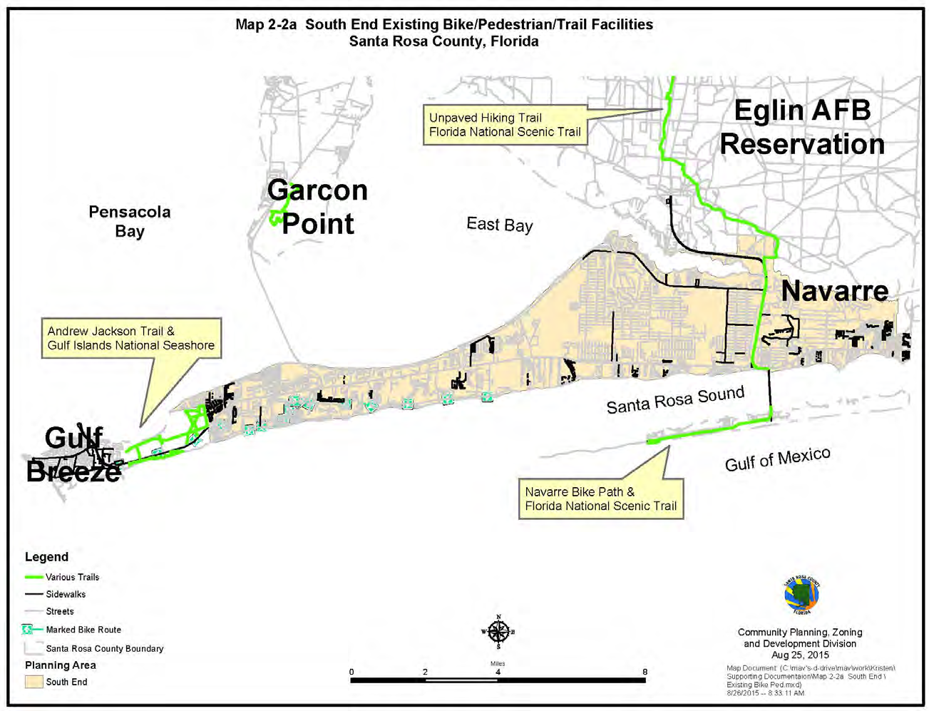
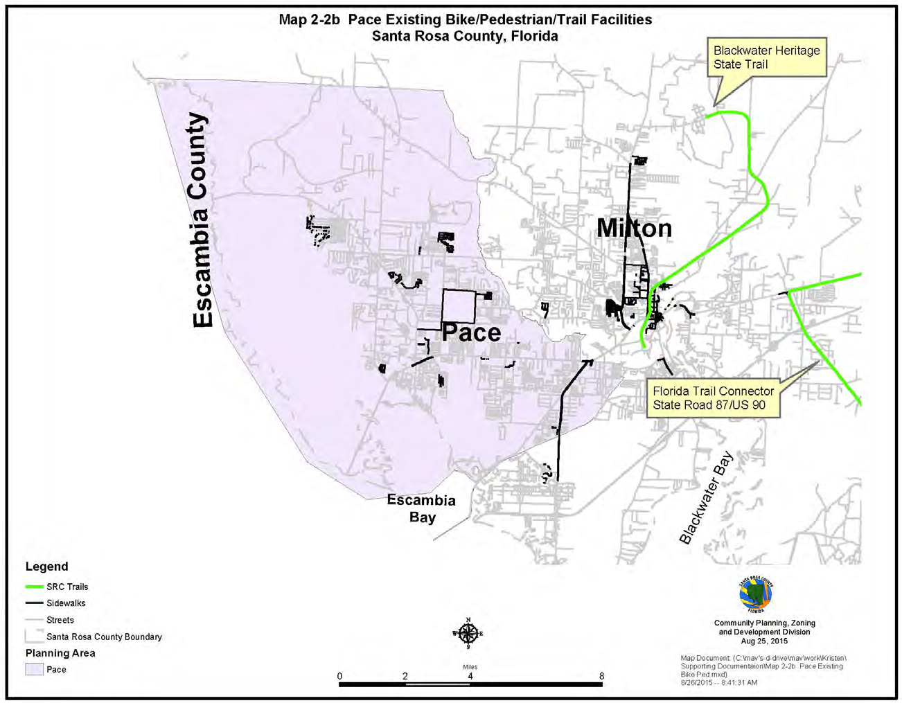
The County fully supports and encourages linking existing facilities and constructing new ones in order to create a contiguous bike/ped system. As a result, the County supports FDOT's policy to build sidewalks and bicycle lanes as part of all new construction and capacity expansion. Santa Rosa County also encourages the construction of these facilities in smaller projects like resurfacing and intersection projects when feasible. The following Map Series, Maps 2-2a , and 2-2b show the existing bicycle and pedestrian infrastructure in Santa Rosa County's urbanizing planning areas including trails.
2.8.6.2 Santa Rosa County Trail System
The mild climate in Santa Rosa County encourages almost year-round participation in non-motorized transportation modes, such as jogging, walking, and bicycling. There are several major multi-use trails in the County.
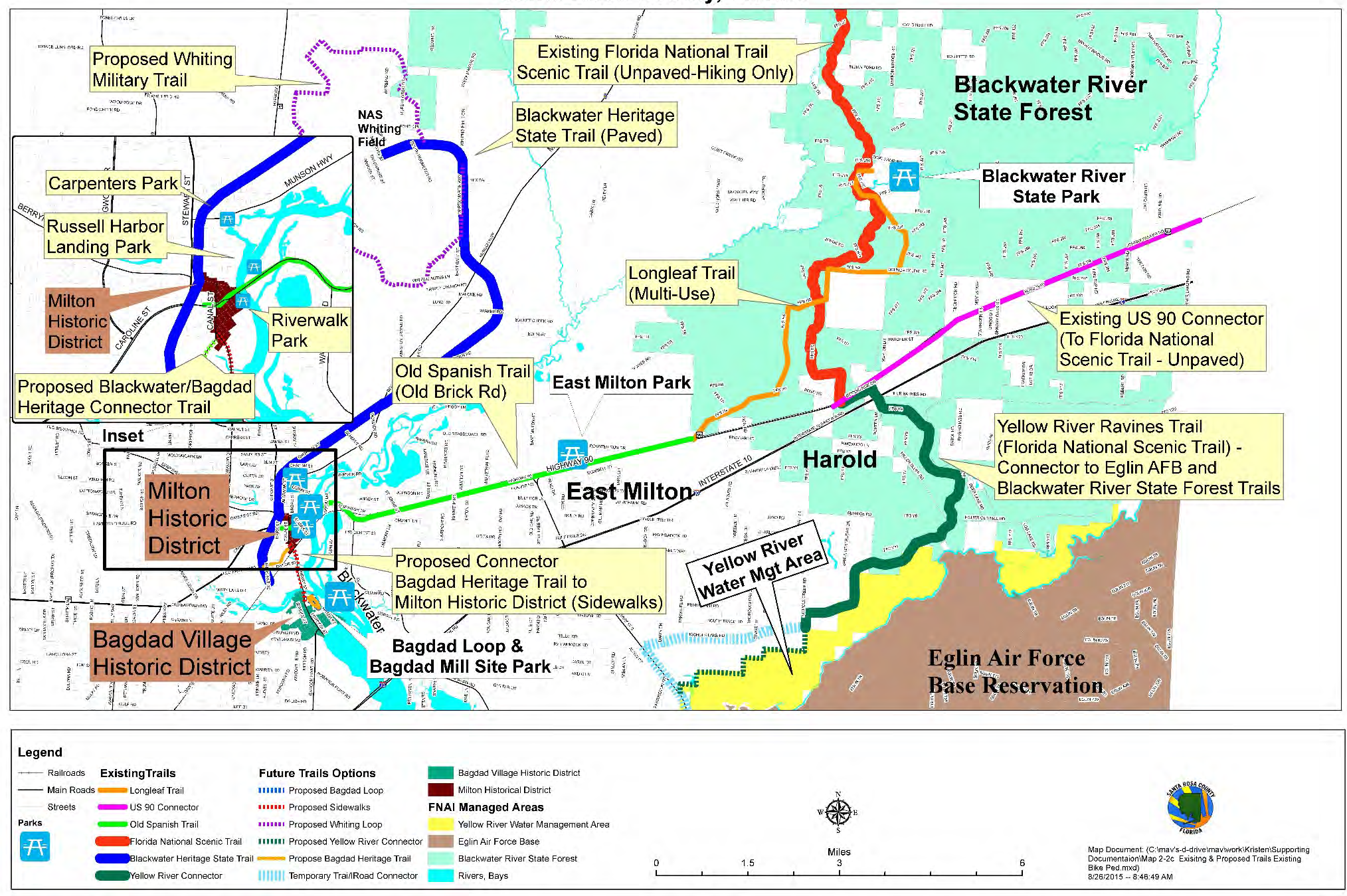
The Blackwater Heritage Trail extends north and south of US 90 in the Milton area. Six miles of the Old State Road 1, parallel to US 90 in East Milton, was also recently rehabilitated. The Old State Road 1, also known as the Old Brick Road, serves bicyclists and pedestrians and connects downtown Milton with the Blackwater River State Forest trail system. Map 2-2c depicts existing and planned trails within the northern half of Santa Rosa County.
In the south end planning area, the multi-use path along the Gulf Islands National Seashore extends along US98 in the south end of the County. Before 2004, a multi-use trail connected Navarre Beach to Pensacola Beach through the Gulf Islands National Seashore. Because of recurring hurricane damage, the portion through the Gulf Islands National Seashore has been rebuilt as a paved shoulder or bike lane on the roadway. The multi-use path, separate from the roadway, remains in Navarre Beach along Gulf Boulevard.